Problem with through route at Scoreby Lodge/A1079 Dunnington
12th September 2025
After contact with the landowner, the gate will be left unlocked and possibly open for most of the time. Investigations are ongoing to determine the legal status.
18th August 2025
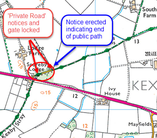
The 200m private road section leaving the A1079 at Scoreby Lodge, Dunnington that continues as a bridleway has a problem. It has come to light that when the definitive map was created this short section was not registered as a public right of way. The landowner has erected notices and the field gate has been getting locked. Investigations are in hand with City of York Council's Definitive Map Team for the issue to be resolved.
22/06/2017- Please note that, between Youlthorpe and Full Sutton, the two cattle grids noted on page 30 of the guide have been removed. The route on this page is otherwise unaltered.
2021 Amendments to route between Lockington and Kilnwick (2013 edition of guidebook).
Page 9, paragraph 1, line 16.
The bridleway crossing the field diagonally, has been diverted to the field edges.
Emerge from the wood and turn right (E) with the wood on our right. Walk to the end of the field, then left (N) with the boundary on your right, to reach the road near Kilnwick.
Continue from line 21, turning left on Church Lane.
Page 11, paragraph 3, line 13.
A new right-of-way has been created here, which you may prefer to use.
After the small gate, turn left, keeping the wood on your left, to re-join the original route at paragraph 4, line 6, continuing (W) over the bridge.
Ray Wallis, December 2021.